


The last few years have seen headline after headline talk about how much of a 'mess' the City Centre is in terms of transport. Whether it be parking, confusing bus lanes (and buses being held up), the GV lane on Queen Street, loading and delivery, enforcement (or lack thereof), congestion, safety, driving, walking, cycling, or more, there seems to be no end of issues with how we are addressing our transport needs.
Many of the feelings people have, and their frustrations and concerns, are valid. However, right now they are not being directed at the true issue - the highly supported, comprehensive, and evidence-based solution to these needs, is not being implemented. And to be quite frank, it sure feels like it is being undermined (even if not intentionally).
Greater Auckland is brought to you by a largely volunteer crew and made possible by generous donations from our readers and fans. If you’d like to support our work, you can join our circle of supporters here, or support us on Substack!
What is this plan?
Over four years ago in 2020, the City Centre Masterplan refresh was completed and subsequently approved by Auckland Council. A core part of that refresh was the highly supported (82%) Access for Everyone (A4E); a strategy to manage transport in the City Centre.
As A4E states:
Access for Everyone (A4E) is a coordinated response that manages Auckland's city centre transport needs by:
limiting motorised through-traffic
prioritising access to city centre destinations
creating new spaces
improving access for servicing, freight and delivery
favouring public transport, walking and cycling.
Additionally, it also sought to create a zero emissions area in the City Centre, as it is one of worst hotspots for black carbon in the country. The end result would the creation of different 'neighbourhoods', where space efficient transport modes are prioritised.

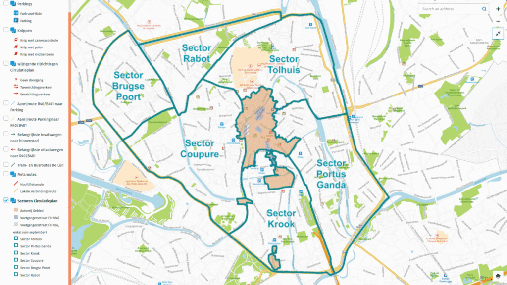
Integral to delivering A4E and achieving these benefits is the development of a traffic circulation plan, which manages how vehicles and people travel in, out, and around the City Centre. To put it simply: by removing through traffic in the City Centre and designating transit corridors, we can create a space that works for everyone.
Remember this, the core of A4E is the traffic circulation plans. Everything else comes from this - people friendly spaces, efficient public transport, parking, freight, delivery and loading zones, and yes proper management of car traffic.
If we do this properly, we create an intuitive transport network for people - regardless of how they travel. It's a very simple concept, and these diagrams are great to understand:

It's proven to work!
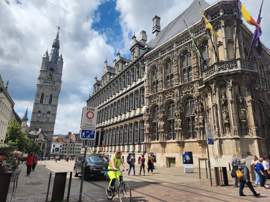
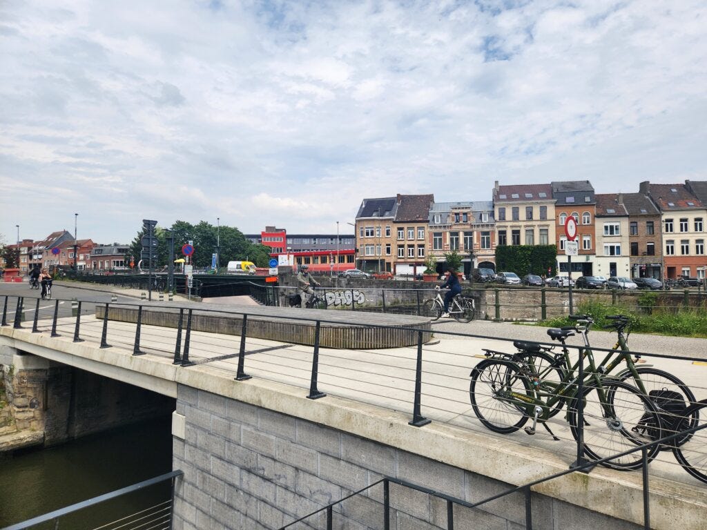
Overseas, the implementation of similar plans has lead to amazing results. Ghent, in Belgium, is the prime example of the transformation circulation plans bring. By changing how space was used, Ghent has become a vibrant people friendly place, where the 'air tastes better', where 'People put their chairs out in the summer to sit on the pavement and talk', where 'The city centre is fun to hang around in all day'.
The champion of the program, Ghent's Deputy Mayor Filip Watteeuw said that “One resident described me as the best orchestral composer the city has ever had,” due to how the city became much quieter after the implementation of the plan. By removing through-traffic, the city becomes accessible for everyone - including those who need to drive as there are far less vehicles on the streets.
This was implemented over one weekend in 2017 at the cost of just €4m ($7m NZD) with cheap tools like bollards and barriers. Persistence and grit were needed but it was incredibly well communicated with maps, apps and more. You can read about how it all works in our post from 2020.
Or about the results as Pippa Coom highlighted them earlier this year:
The positive experience of a more welcoming atmosphere is backed up by measured impacts. Since 2017, Ghent has seen:
18% reduction in air pollution (with a slight increase on the ring road)
20% fewer cars in the city centre
Increase in PT usage
Increase in cycling mode share from 22% to 37%
Car journeys reduced from 55% to 27% mode share
37% decrease in traffic incidents.
Editor’s note:
The boons are also economic: a 2019 report (covered in English here) noted a 20% boom in the hotel and restaurant industry in the two years after the circulation plan was introduced.
The circulation plan and its ongoing positive feedback loop are also key to the city of Ghent’s climate plan.
But the point is it worked wonderfully. And we have our own strategy here in A4E that, based on Ghents example, could be implemented overnight and cheaply with the right circulation plans.
What's happening in Auckland's City Centre?
If A4E would be extremely beneficial, and is official Auckland Council policy, you might ask where are the City Centre circulation plans?
That's is a good question. Because as far as I can tell, apart from the case study used in the development of A4E in 2019, AT still haven't gotten past the concept stage for the circulation plans.

After 2020, AT had gone out to develop a 'Programme Business Case' for A4E. This was finished in 2022, so what did it produce?
It starts off well, identifying the core purposes of A4E:
Firstly, it is a movement circulation plan that creates space for efficient or desirable activities such as walking, cycling and public transport. It does this by restricting the movements of private vehicles through Tāmaki Makaurau’s city centre to specific streets.
Secondly, Access for Everyone is a coordination programme for the city centre. It creates a strategic framework to organise, monitor and prioritise city centre projects while minimising disruption and enable quality engagement with stakeholders.
Yet, while identifying a circulation plan as a prefered option to achieve A4E's outcomes, only a concept plan was produced, no detailed work at all.

The PBC slated this to cost $386.2 million over 10 years, with a BCR between 1.7 to 3.3. But keep in mind that is all of the fancy stuff and, as per Ghent, there is no reason other than choosing not to we could not implemented the core concept cheaply to get all the benefits - then building all the niceties over time.
Regardless, the PBC also identified a longlist & shortlist of interventions. But again, the core of the entire strategy is the circulation plans and detailed work on that is missing.
And not having that core part has had consequences for the City Centre.

The battle for Queen Street
In 2020 Covid actually provided an opportunity to accelerate some of the core features of A4E. We first got going through a pilot on Queen Street, the trunk of A4E as a pedestrian and rapid transit corridor. Auckland Council produced an amazing video explaining the goals of the pilot, and A4E as a whole, and how it would transform the City Centre from a 'space to drive through, to a place to go to'.
This was unanamously supported by Council at the time, yet it got watered down by officials and Auckland Transport, only to then get further scuppered by legal action and backroom deals through 2021 - all against public support. While we did get streetscape upgrades, we still have cars on Queen Street - the trunk of A4E. Well, except for the one tiny part between Wakefield & Wellesley, the 'GV' or 'EV' lane that's far more unintuitive than just removing vehicles from all of Queen Street.
As Matt said in 2020, 'Why is this so hard'.
Take to the kerbs
Currently, Auckland Transport has been working on a management plan under Room to Move to deal with kerbside use - parking, loading, delivery and the like. This work is ongoing, including in the City Centre, as seen in this workshop briefing earlier this year. With all the stories in the media right now, it might be of some comfort that solutions are allegedly coming, as the use of kerb space in the City Centre is a complete mess.
Yet this work is being done without having the strategic foundation of A4E. Not once in that workshop briefing does it mention a circulation plan, only referring to a vague 'long-term vision' from A4E and inference from a map.
And so while the programme team has been working in incredible detail, they are missing the fundamental component.

It means this vital and much needed work is being done in a vacuum, if your process is missing the most important aspect how are you going to get the best outcomes?
Knowing how people are able to travel would make the R2M programme far easier to develop and implement (and for the public to understand). It feels like it's doomed to fall short of its goals, despite the hard work that's ongoing.
A vacuum leads to undermining
Other areas hampered by the failure to produce the circulation plans is around the City Rail Link Stations on Karangahape Road/Pitt Street, Victoria Street, and Albert Street. Identified on the shortlist of the PBC as a high priority due to the opportunity to piggyback off of the CRL work, these areas could have implemented the first 'neighbourhoods' in A4E.
Yet, most egregiously around K' Road, it is likely this isn't going to occur. And, much like Queen Street, the lack of the central strategy has meant A4E is being undermined by dubious means. The Karanga-a-Hape Station Precinct Intergration works did include a circulation plan, as seen here from a few months ago:
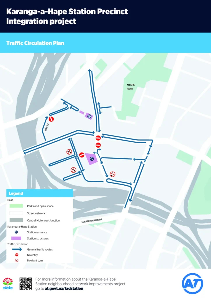
It wasn't ideal as it was missing the restriction of general traffic on K' Road to create a transit lane (anyone who has been on a bus through K'Road will understand this is a problem), but at least it created a no through-traffic zone on Day Street and Mercury lane. This was supported in consultation by 67% of people, and 44% from K' Road area (with 32% opposed).
Except, due to the backroom lobbying by a small number of people, which you can see here from this LGOIMA in this google drive, Auckland Transport has relented and this is now the circulation plan:
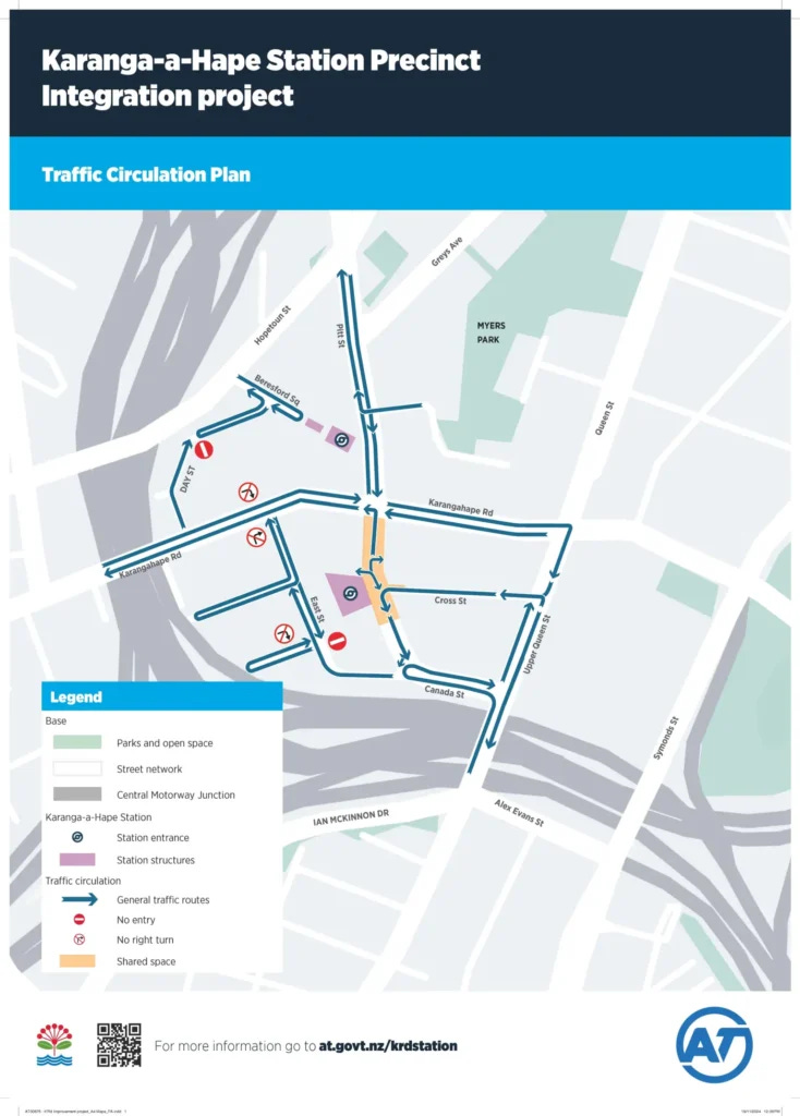
In fact, as I was writing this post I found AT has seemingly stealth edited the project webpage, which incidentally obscures the fact it made this decision due to the minority of voices.
Here's what it said initially after they moved towards this change (as seen on Wayback Machine):
In 2023, Auckland Transport proposed:
permanently restricting motor vehicle access in the upper section of Mercury Lane
making that section a pedestrian mall.
67% of survey participants supported the proposed access changes and 20% opposed. However, when we asked only those living in the Karangahape neighbourhood, support reduced to 44% and opposition increased to 32%.
We then met with affected residents, businesses, and property owners to further discuss the proposal.
The community raised concerns about access for friends, family, visitors and couriers. Another worry was that NZ Police might reduce the number of patrols in the area.
We have deferred the proposal until after Karanga-a-Hape Station opens. After our Traffic Control Committee finishes formalisation, the upper section of Mercury Lane will open as a shared space. We will install line marking and signage as part of the finished works, including a loading zone.
The lane will otherwise only be for northbound, moving traffic. No parking will be available.
And this is what it says now:
When construction is complete, the upper section of Mercury Lane will open as a shared space, depending on the formal approval from the Traffic Control Committee.
We previously announced that upper Mercury Lane would become a pedestrian mall when Karanga-a-Hape Station opens and would operate as a shared space in the meantime. This was based on feedback from public consultation.
However, the proposal to proceed to a pedestrian mall has been deferred until after Karanga-a-Hape Station opens. This is due to the complexity of the process as there are slightly different operational requirements for each section.
The shared space will extend along Mercury Lane from south of the station to the top by Karangahape Road and includes a short section of Cross Street. A special road surface, signage and street furniture will indicate to drivers that this is a slow-speed, shared space where pedestrians have priority. No parking will be available in the shared space.
Auckland Transport’s Network Operations team will monitor the use and safety of the space to determine when further changes may be needed after the station opens. If the shared space is used as safely as intended there may not need to be further changes.
The overall design and construction for Mercury Lane remains the same for a shared space and a pedestrian mall. A shared space requires additional signage, monitoring and road markings, which can easily be removed if required. A pedestrian mall requires physical restrictions for vehicle access. Retractable bollards will be installed during construction to enable this. The bollards will also be installed to protect the station in emergency situations and to close off Mercury Lane for public events.
AT have backed away from removing through traffic, instead implementing a shared space which as anyone who lives in or frequents the city centre knows is just a free for all for cars - reducing safety for pedestrians.
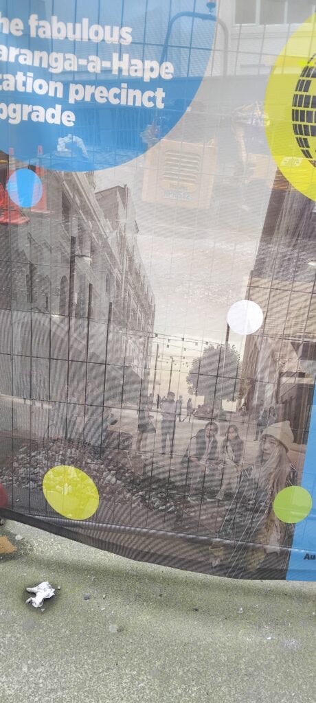
To be clear I do not blame the AT project team for this, all evidence from the LGOIMA indicates decisions were made over their heads, but it doesn't mean the outcome isn't bad. Theres no guide for the team, no foundation for them to point to when the vocal minority pushes back. So it gets undermined. Which makes it ironic that they use these renderings outside of the construction work now the space is going to be filled with cars:
The Mercury Lane sage deserves its own post due to the skullduggery that's occurred, but the point is you have an area that will see thousands of people from the CRL stations and a hugely supported strategy being undermined by a tiny number of voices because we have not developed the fundamental part of A4E.
Why this matters
When we look at all these issues in the City Centre, and we think about how we are currently able to travel within (not-withstanding construction), it feels like a hodge-podge of things that has no logic to anyone - however you travel. Bringing order to this chaotic approach is found in A4E's circulation plans.
A4E is a pertinent example with how we seem to keep doing transport in Auckland - a lack of boldness and will to truly transform our city. This lack of vision, and refusal of our agencies to accept any, creates a vacuum that wastes our cities potential (and money).
In my opinion, A4E is currently trapped in the cycle of business case hell. In other words, it's being delayed out of existence. If we lose it we lose the foundation of the circulation plans that will create areas that can unleash our streets as spaces for people. A4E is vital as it will make our City Centre the place to be and create an intuitive transport network for everyone.
And fundamentally, while individual projects and individual AT staff are valiantly trying to solve problems - they are doing so without a solid foundation. This means any actions are merely tinkering on a flawed system that no one is happy with.
While many people will mention ongoing construction disruption as a reason not to do things, the same excuse used for scuppering Queen Street except with Covid disruption, it actually presents an opportunity to do these transformational changes as the status quo is already in flux.
The circulation plans for the City Centre are the key ingredient to make it all work. If we want to deal with transport problems and meet our needs in the City Centre we need A4E.
Doing anything else is just trying to build something on quicksand. And right now AT and AC are going in circles. Much like we will continue to go in circles with our issues and complaints.
Instead, lets get circulating with A4E.