


Weekly Roundup 22-August-2025

Another Friday closer to actual spring, and here’s another roundup of insights from the world of urbanism. As always, feel free to share your links to stories on transport, cities, and what makes them great. Our header image this week shows the cycleway ramp for Sydney Harbour Bridge, currently under construction. That could be us, you know.
This Week in Greater Auckland
On Monday, Patrick made the case for why the City Rail Link is a bargain, and why smarter funding for Infrastructure of National Significance must be part of any “city deal” for Auckland.
On Wednesday, Matt weighed in on the age-old debate about New Zealand’s outlier approach to compulsory bike helmets, which got dragged into the headlines again after David Seymour considered cutting that piece of red tape… and then decided against. DO read the comments, in which this topic gets the grown-up discussion it deserves.
In Thursday’s post, Scott (aka scoot!, Coalition for More Homes spokesperson and aspiring Wellington mayoral candidate) dug into the latest zoning reforms proposed for Auckland, which include up-zoning along frequent transit routes. Scott also had a persuasive chat with Mike Hosking on the topic, and was quoted in this Herald story (paywalled).On Thursday morning, Council gave the green light to the changes, as reported by the NZ Herald:
All but two councillors – Mike Lee and John Watson – voted to approve the draft replacement plan for consultation with Local Boards, iwi, neighbouring councils and government ministries. The plan will return to councillors on September 24 for a decision between adopting the new proposal or continuing with Plan Change 78, which addresses the MDRS.
Given the strong support shown today, it’s highly likely councillors will opt for the draft replacement plan. If so, it will proceed to public consultation at the end of October, with submissions closing before Christmas.
This roundup, like all our work, is brought to you by the Greater Auckland crew and made possible by generous donations from our readers and fans. If you’d like to support our work, you can join our circle of supporters here, or support us on Substack.
Note: We continue to experience some glitches with our mail-outs to social media and to our subscribers. Please contact us if you’re having any issues. And thank you for your patience while we sort this out!
Wait, what? Scoot’s running for Mayor? Of Wellington?
Call it commitment to the bit: it’s one way to highlight the topics that need to be discussed. As noted by BusinessDesk, while it’s unconventional to not actually live in the city you seek to lead, it’s not necessarily a disqualifying matter:
Scott “Scoot” Caldwell has put his nomination in for the mayoralty, and in a press release noted that “Mr Caldwell visited Wellington for the first time in June 2025 and that trip alone solidified his resolve to run for mayor of New Zealand’s capital city”.
Caldwell is known for his association with the Coalition for More Homes, an organisation that has a giant Sky Tower in its logo and advocates urban intensification as a way to increase housing supply.
“Wellington needs to reject curtain twitchers trapped in the 1980s and embrace growth: for affordable housing, for rates relief, for great infrastructure, for thriving businesses,” Caldwell said. Caldwell defines 1980s curtain twitchers as people who “actively seek to incite moral panic in any minor change in their city”.
“Their fetish for heritage-listing broken or useless things has created a culture of fear of change and modernisation. Wellington is left holding its trousers as the world leaves it behind.”
If history is any guide, Caldwell not being located in Wellington may not be a handicap.
Auckland’s Newest Cycleway
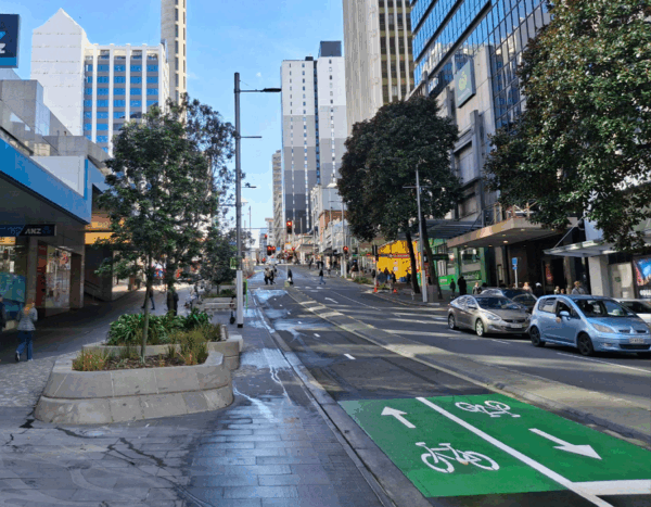
Last Friday Auckland’s newest cycleway finally opened along Victoria St.
Aucklanders are able to move around more of the city centre on two wheels, as the section of cycleway along Victoria Street from Federal Street through to Queen Street is now open.
The new two-way cycleway along Victoria Street West, connects Victoria Park and the Nelson Street cycleway to Queen Street – a vital link in the city centre’s cycle network.
The cycleway has been designed to keep riders physically separate from traffic, offering a protected route. It’s the latest milestone in the regeneration of midtown.
School streets, here and abroad
Paris now has over 300 “school streets”, almost twice as many as last year. Check out some beautiful before and after slider images here, to see how they’ve evolved. There’s also a beautiful mini-documentary by StreetFilms.
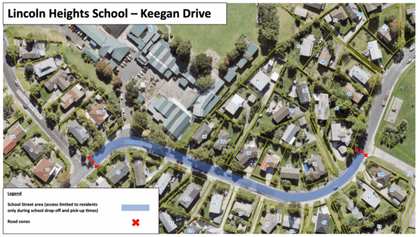
But wait! We can have nice things, too. Auckland Transport is implementing a “school street” for Lincoln Heights School, where illegal parking at busy times is making the street dangerous and inaccessible for tamariki and residents alike.
Enter: our friend… the traffic cone! It’s as simple as that. More of this please, everywhere.
The Changes We’re Making:
Setting up cones from #13 Keegan Drive to #42 Keegan Drive to create a barrier during school pick up (8.15am to 9.15am) and drop off times (2.15pm to 3.15pm)
Installing “School Street” signs indicating the time the road is being closed during school days
Restricted access is for non-residents during the scheduled times. There will be an assigned staff member managing the traffic cones to ensure access for residents.
Incoming: another bit of bike network!
On Tuesday, the Waitematā Local Board gave the thumbs up to AT’s plan for walking and cycling improvements to Surrey Crescent and Old Mill Road, to be delivered along with upcoming road renewals.
Longtime readers will spot this as a significant chunk of the long-planned Waitematā Safe Routes for cycling, linking Great North Road through to the new Point Chevalier to Westmere bike paths. For ten years, this network has had strong local support, including from the local business association, the residents’ association and Grey Lynn School.
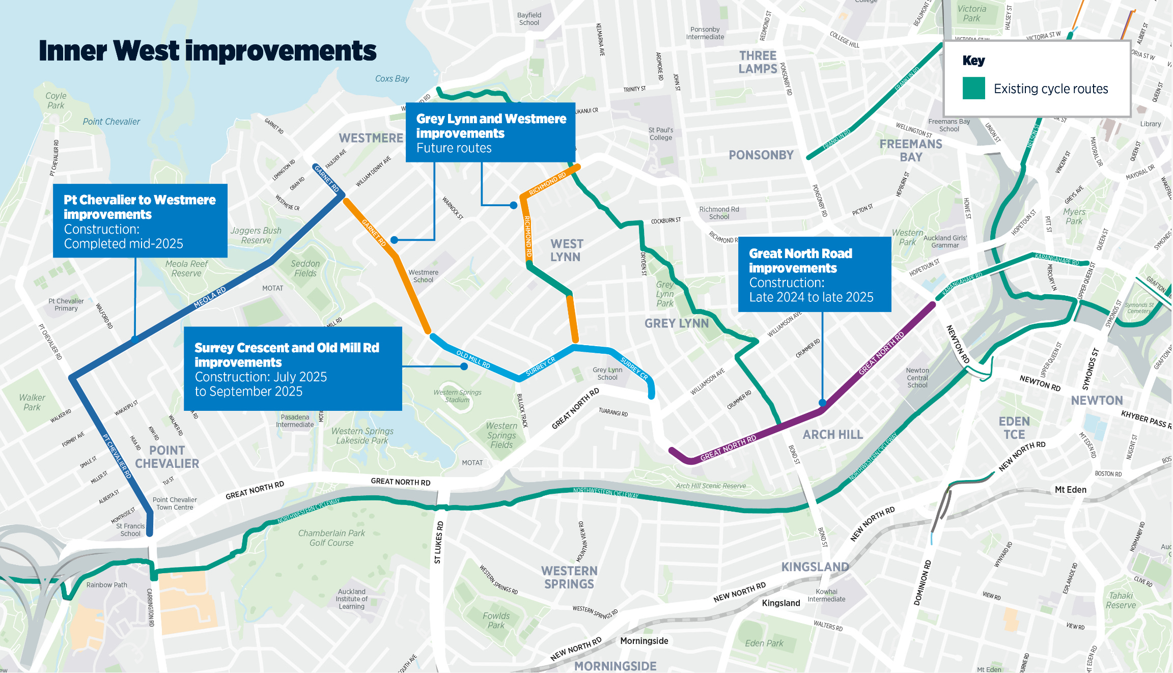
What’s being delivered now is a partial, low-res version of the original hi-spec vision (for which AT didn’t manage to secure funding). The plans show a combination of on-road and off-road bike lanes, and some sections of shared path including through the Surrey/ Richmond intersection. The major intersections could benefit from more robust design, but that’s dependent on (future) funding.
For now, most of the action is on Surrey Crescent, with AT noting: “Planned road resurfacing on Old Mill Road will be carried out in the next 3-6 years and the on-road cycling improvements in this section will be delivered at the same time.”
Two key puzzle pieces remain for completing the Inner West network: the glaring Bermuda Triangle at the Grey Lynn shops (Great North Road/ Williamson), and lovely wide Garnet Road, from Old Mill Road past Westmere School to the Meola roundabout, which looks like an easy win.

Image: via Bike AKL, showing the Bike 2 the Future ride 2018 heading up Garnet Road.
We’re walking here!
Smartphones offer a “natural experiment” in tracking walking patterns. Research based on US data finds that the more walkable the city, the higher your daily step count. Who knew! Apart from everyone who’s ever glanced at their pedometer stats after going on holiday somewhere nice.
For example, moving from a less walkable (25th percentile) city to a more walkable city (75th percentile) increased walking by 1,100 daily steps, on average. These changes hold across different genders, ages and body mass index values, and are sustained over 3 months. The added activity is predominantly composed of moderate-to-vigorous physical activity, which is linked to an array of associated health benefits.
Meanwhile, robots confirm that people in cities walk faster, and socialise less. Writes Carlo Ratti, the director of the Venice Biennale Architettura:
Together with colleagues at Yale, Harvard and other universities, we used AI to compare footage of public spaces from the 1970s with recent video in the same locations in New York, Boston, and Philadelphia. The findings are striking: people walk faster, linger less, and are less likely to meet up.
And new Auckland-based research, covered by Newsroom, confirms the importance of making cities attractive for walking:
In our study of Auckland’s walking patterns, we found that the suburbs with the highest levels of foot traffic were populated by people who had to walk to get where they needed to go, rather than choosing to walk for the pleasure of it.
The foot traffic in affluent neighbourhoods, by contrast, with leafy boulevards and vibrant high streets was more commonly populated by people walking for pleasure. That is, people chose to walk because it’s a pleasant thing to do, not because they had to.
The network disruption cost of crashes
An interesting study out of Auckland Transport looks at the knock-on effects of serious crashes across the wider network.
This small scale pilot research study examined recorded travel times on road links around 4 serious crash sites to identify where it is likely that the crash and resulting lane or road closures caused additional delays on the road network.
One of the takeaways of this study is that including the impact of disruptive crashes in cost-benefit analyses of safety projects could increase the value of those project substantially. The authors note this is a small study and the variables are large, but the implications seem pretty clear:
For example, the average network disruption cost of the four crashes studied is at least $400,000. While there is little confidence that this represents the actual average disruption cost of serious crashes in Auckland, due to the small sample size[,] if the actual average cost of disruption due to serious crashes in Auckland is, for example, $50,000, the annual cost of disruption due to serious crashes in Auckland would be about $27 million, or $270 million over 10 years.
In addition, minor injury crashes, depending on their location and level of disruption, can lead to as much unexpected network delay as a serious crash. There are more than 2,500 reported minor crashes per year on Auckland’s network. If the cost of disruption from each minor injury crash is $10,000, that would add equate to $25 million of network disruption annually and suggests that the cost of network disruption due to all crashes in Auckland over 10 years might be about $500 million.
File under ‘but why’ (or ‘bit weird’)
The East Auckland Times reports that a third-year law student, representing himself, has won a judicial review over speed-calming treatments (a raised crossing and three speed bumps) on The Parade, in Bucklands Beach.
As noted earlier by Local Board chairperson Damian Light, the works were designed to improve safety at a location known to be dangerous:
…there had been numerous crashes on the road, particularly near the intersection of The Parade and Laings Road, which he described as “quite a blind corner”.
“We know we’ve got issues as there’s no footpath on one side of The Parade so people have to use the other side. We want people to get across safely.
“That’s what the pedestrian crossing is for. The speed bumps are intended to slow vehicles down, so if a pedestrian gets hit they won’t be killed.
“Because 50mk/h will kill you, whereas 30km/h is a survivable speed.”
The judgement seems to rest on a persuasive reading of part of the Local Government Act 1974, which says local authorities should not “unduly impede” vehicular flow; and on the question of whether AT had made up its mind before consulting or informing the community.
Auckland Transport, the road-controlling agency with the statutory duty to provide a safe transport system, is “in the process of considering the High Court’s decision.”
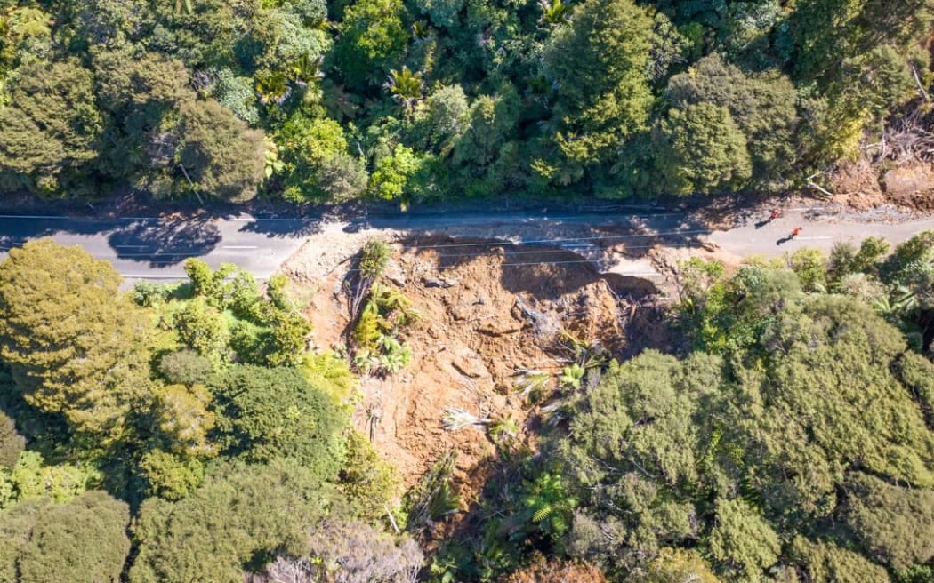
A new milestone in flood and cyclone recovery
An interesting piece from RNZ on AT’s progress on recovering from the floods and cyclone of early 2023. In this case, focusing on the damage and rebuilding of Scenic Dr in the Waitakere Ranges.
The view is stunning – from high up in the Waitākere ranges, you can see all the way out east to downtown Auckland, the Sky Tower and the harbour, with Rangitoto Island visible on the horizon.
But until Cyclone Gabrielle and the storms of 2023 hit, this particular view did not exist at this spot on Scenic Drive.
Two and a half years ago, a wall of water, mud, trees and rocks smashed its way down onto the roadway, demolishing the road and carving a path 60 metres down the hill.
Now the road has been put back together again, but the view smashed out of the thick bush still shows off nature’s power.
After close to three years of closure, the full road between West Auckland’s Titirangi and Piha will finally reopen on Friday.
It has taken millions of dollars and the labour of hundreds of workers to get here.
Two petitions worthy of your support
Make Te Atatū Peninsula roads safer: a call for “urgent action to address the increasing threat of reckless driving on our streets”, started by a resident who was seriously injured while walking outside his house earlier this year.
Bring back long-distance passenger rail to Taranaki: a call to “reinstate regular passenger rail services between New Plymouth, Whanganui, Palmerston North and Wellington; reconnecting communities across the North Island with safe, sustainable, and inclusive public transport.”
News from elsewhere
In North Canterbury, schools fear unintended consequences of tolling the new Woodend Bypass, reports Stuff:
Kaiapoi North School has been working with the Waimakariri District Council to address safety concerns outside the school. “We are worried about the impact it will have on the safety of our children and their families,” principal Jason Miles said. He said the school’s board of trustees will be discussing whether to make a submission.
Te Kura o Tuahiwi and the Tuahiwi Marae have worked with the Waimakariri District Council on safety improvements on Revells Road, Tuahiwi.”We are quite isolated, but we do get trucks coming through. It is another thing to worry about in keeping our tamariki safe before and after school,” Te Kura o Tuahiwi principal Dot Singh said.
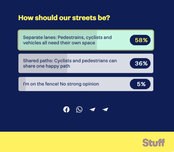
Strange scenes in Christchurch, where the incumbent mayor (standing for re-election) is proposing to tear out a protected cycleway on one of the most peopled routes in the city, Park Terrace which runs past the Arts Centre and Canterbury Museum. He wants to make people ride on the footpath instead. The article has the usual hundreds of comments; the related poll with over 10,000 responses suggests he’s on the wrong track here.
Inspiration corner…
Helsinki reports zero traffic deaths in the last twelve months. The secret to their success? The usual evidence-based, data-driven mix of safe speeds, better street design, lots of alternatives to driving, and good enforcement. It’s really not rocket science.
The positive trend extends beyond fatalities. In the past year, there were 277 injury-causing traffic accidents in Helsinki — a sharp contrast to the nearly 1,000 injurious accidents recorded annually in the late 1980s, when traffic deaths in the city commonly approached 30 per year.
And in Paris, outside City Hall you can’t see the cobblestones for the trees.
Meanwhile in Sydney, work is proceeding on a $29m ramp that will make it a breeze for people on bikes to access the Harbour Bridge. Currently, you have to haul your bike up (or down) 55 steps. The ramp with its bronze balustrades looks beautiful. And so does biking across a bridge, to be frank.
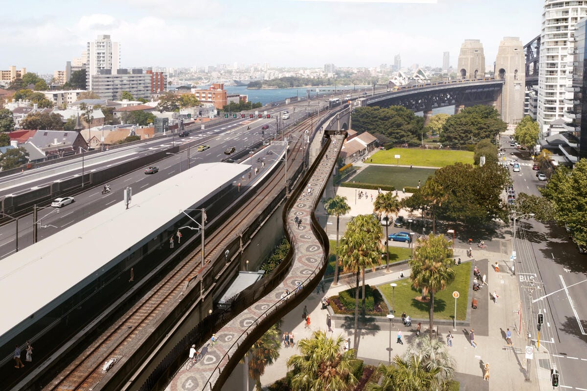
Image: Transport for NSW
That’s us for this week. Have a great weekend!
Thanks - Inspiration corner was very "inspiring" this week. Love the transformation of the square in front of the Paris City Hall and as a previous resident cyclist of Sydney, the brilliant ramp to the Harbour Bridge